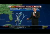
sc ario two, goes into new york city or further north. now we have winds of 15 to 25 miles per hour. rain, just showers. don't see any flooding with scenario two. scenario three, now we're tracking it a little further south, northeast pennsylvania and northern new jersey, winds of 20 to 40, rain, perhaps an inch or less. scenario four, a 25% chance, it goes into northeast maryland or southeast pennsylvania. this could be a disaster. 40 to 70-mile-per-hour winds, two to four inches of rain. this is generally the circle of where most of the damage would occur, and that would include pretty much the entire metro area. we haven't talked about it yet but it is possible in the mountains above about 2,000 feet west of the divide, and in the allegheny mountains north in pennsylvania they could even get some snow on the back side of this storm. that's the way it looks. again, scenario four not so good. any questions about the scenario? >> so a one in four chance of the scenario happening that we really don't want. when would you be able to tell us
 Live Music Archive
 Librivox Free Audio
 Metropolitan Museum
 Cleveland Museum of Art
 Internet Arcade
 Console Living Room
 Books to Borrow
 Open Library
 TV News
 Understanding 9/11